
Yes, what you are reading is right, all maps around the world are wrong. So, what is the correct size of the countries in the world? For that one has to look at the existing and most widely used map that have been used in schools, colleges etc., but if we talk about proper representation of the countries, this map is incorrect. All world maps that are currently and most widely used, including the google maps, are incorrect. The problem with these maps is that these maps were made using Mercator Projection developed by a famous German Cartographer, Mercator. In 1569, he made a map himself and named it Mercator map. During this time, it was proven that the earth is round but the sailors travelling from various places needed a map to determine their safest route and the location of their destination, therefore to solve these issues, Mercator made a map on a cylinder and took the light source in 00 and projected the map in a flat surface. This is how the Mercator Projection was made in 1569, which is still used in 2023 in our books. 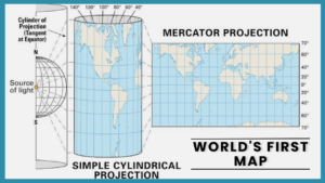
The problems in this map are basic, the countries in the middle of this map i.e., countries near the equator are smallerbut as one goes to the north the countries size would become bigger. So, this map shows the world in an incorrect way, the northern countries would look bigger than they actually are and the countries in south would look smaller than their actual size. For example; Russia, which the largest country in the world, may look like it could hold China, India, USA and various small countries but if Russia was located near the Equator, it would look smaller than its presented size. This shows that Mercator map is distorted.
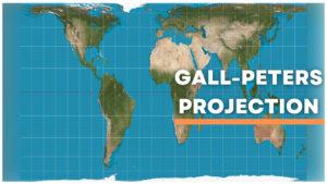
Gall-Peters Projection
Some would say that if this map has so many problems, is there any other maps, there are various books that says there are other maps but Mercator map is mostly used because there is biasness as it was made by a European and this map shows the western countries bigger than their actual size and nobody thought of changing it. There are different maps for example, nowadays a different map is being used that is, Gall-Peters Projection map which is being used by various US states and African Universities. Gall-Peters Projection is a rectangular, equal-area map projection. Like all equal-area projection, it distorts most shapes. It is a cylindrical equal-area projection with latitudes 450 north and south as the region on the map that have no distortion. This map, if not 100%, is more accurate than Mercator Map.
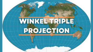
Winkel Triple Projection
Another type of map that many countries like is Winkel Triple Projection map.This map has preserved most of the countries size as much as possible in a flat surface. This map is a modified azimuthal map projection of the world, and is one of the three projections proposed by a German cartographer Oswald Winkel in 1921. This map is most accurate but it is not available in high quality. This map shows the accurate size of all the countries.
As a learner, if one wants to learn about countries and its proper size it is best to refer a globe, which is easily available in market, and place it on the table of a room. Globe is the best way to know about the actual sizes and maps of various countries in the world. Most of the world leaders have a globe in their table.
FAQ:
What is world map?
A world map is a map of most or all of the earth’s surface. World maps have to deal with projection issues because of their scale. A map rendered in two dimensions necessarily distorts the representation of the earth’s three-dimensional surface. This is true for any map, but world maps take these distortions to the extreme. Many techniques have been developed to present world maps that address various technical and aesthetic goals.
How many countries are there in the world?
According to the United States Department of State there is a total of 195 counties in the world which are printed in the world map. According to United Nation there are 193 sovereign countries that are a part of United Nation. United Nation is the world’s largest intergovernmental Organization which was made in 1940s.
What are the different types of world maps?
There are thousands of types of world maps, but the most used world maps are Mercator projection map, Gall-peter projection map, Winkel Triple Projection map, just to name a few.